U.S. had 300 tornadoes in April, second-most on record
Following a chaotic swarm of twisting storms in its final week, April’s tornado count in the United States climbed to at least 300, the second highest in the month on record.
Although April is often a busy time for tornadoes, the 300-plus twisters this year dwarfed the average of 182 and trails only the unbelievable total of 757 in April 2011 in modern records, according to a preliminary analysis by the National Weather Service Storm Prediction Center.
Tornadoes were most numerous in the central states rather than in parts of the country that often record the highest number in April, such as Mississippi and Alabama.
The month also produced the strongest tornado in over a year, several damaging and deadly events, and a twister atop a mountain in Alaska, of all places.
Key numbers
The month opened with dozens of tornadoes in the Midwest, Ohio Valley and into the Mid-Atlantic. Another round swept the Gulf Coast and Southeast around the 10th before a couple of small events midmonth.
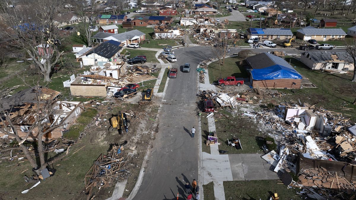
Repeated rounds of violent thunderstorms erupted in the central states during the month’s final six days. Outbreaks on the 26th, 27th, 28th and 30th produced more than 100 tornadoes.
Here are some of the most significant statistics from the month:
• Tornadoes were reported on 18 days according to the Weather Service.
• At least six people died in tornadoes, all in April’s final week. Three tornadoes in Oklahoma took four lives, while Kansas and Iowa each recorded one death.
• Long-track, intense tornadoes crossed eastern Nebraska and western Iowa during an outbreak on April 26. Nineteen tornadoes have been confirmed in the Omaha, Nebraska, area. Five were rated EF3 on the 0-to-5 Enhanced Fujita scale for intensity and were the strongest in the region since June 2014, according to the Weather Service.
• 2024’s first violent tornado, rated EF4, struck April 27 after dark, southeast of Ardmore, near Marietta, Oklahoma. It was the first confirmed EF4 or stronger twister in over a year. It was also the first EF4 in the state since May 9, 2016, according to the Weather Service.
• A tornado occurred in Alaska on a mountaintop near Anchorage on April 19. While it was a landspout – which forms through different processes than typical twisters in the Plains – it was rare. It joins only three or four others documented in Alaska since 1950 and was the earliest to form.
• The Weather Service issued 625 tornado warnings during the month. While a huge number, it’s only about half the count during April 2011, when there were just shy of 1,200 warnings.
• Despite the exceptional April for tornadoes, the Weather Service received an average number of severe thunderstorm reports overall – including instances of large hail and damaging straight-line winds. It received 2,421 such reports compared to the average of 2,184.
April’s tornado count in perspective
April is the third-most active severe weather and tornado month of the year as streams of cold and dry and warm and moist air clash. Its average of 182 tornadoes trails May’s 268 and June’s 213.
While May and June tend to have higher twister totals, April is known for its violent outbreaks, including infamous events in 2011 and 1974.
Still, it can be fickle. When chilly air dominates, storminess is suppressed. But during periods in which warm, humid air surges north from the Gulf of Mexico and collides with the leftover chill from winter, explosive storms can develop. Last month brought frequent surges of humid air northward from the gulf, especially in the month’s final week.
More tornadoes probable in days aheadEvery day from April 25 to Thursday has featured tornadoes, and there’s a legitimate chance this streak will continue for another week or so. Lower-end tornado threats are predicted in the southern and central Plains through the weekend. Then another large system, with the potential to be a major tornado producer, is poised to spill into the central United States early next week.
Beyond that, the forecast is less clear, partly because predictions are less reliable so far into the future and partly because the pattern projected by computer models appears less favorable.
But given the season thus far and the tendency for the central states to be a frequent battleground between cold and warm air, more storminess seems probable well past early next week.